Global Positioning Satellites

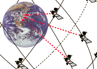
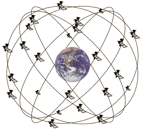
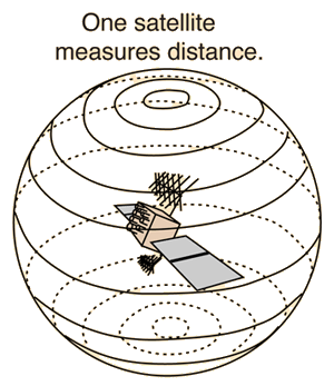
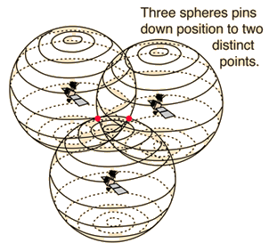
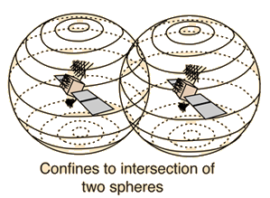
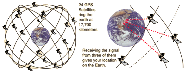
In June of 1993 the last of the 24 satellites of the Global Positioning System was placed into orbit, completing a satellite network capable of providing position data to locate you anywhere on Earth within 30 meters. The satellites carry up to four cesium and rubidium atomic clocks which are periodically updated from a ground station in Colorado. The satellites transmit timing signals and position data. A GPS receiver, which can be a small, hand-held device, decodes the timing signals from several of the satellites, interpreting the arrival times in terms of latitude, longitude, and altitute with an uncertainty which may be as small as 10 meters. In differential mode, accuracies of less than a centimeter can be obtained for distances of hundreds of kilometers. Hand-held units read out longitude and latitude to a thousandth of an arcminute and change in the last decimal place in a couple of paces while walking. The satellites are in orbits much lower than the syncom satellites, orbiting around 17.7 million meters (11000 mi) above the earth, with orbit periods on the order of 10 hours.

From aircraft and ship navigation to finding the favorite fishing hole on the lake, the applications of GPS have multiplied rapidly.

Agricultural applications of GPS
Index

Orbit concepts

Reference
 
HyperPhysics***** Mechanics R Nave
Go Back


Global Positioning Orbits

The 24 satellites of the GPS are placed in orbits at about 3.75 times the radius of the Earth. A GPS receiver, which may be a small hand-held unit, can triangulate its position on the Earth's surface within 30 meters or less with signals from three of the satellites. The satellites are arranged in six orbital planes with four satellites in each plane.

Index

Orbit concepts

Reference
 
HyperPhysics***** Mechanics R Nave
Go Back


GPS Navigation Message

The positioning information from GPS satellites is sent in the form of repeating codes which identify the sending satellite, give locations of the other satellites in the system, and give the navigation data. The codes which form the GPS signal structure are superimposed upon two carrier waves in the L-band, a frequency range set aside for satellite communication. Both the carrier frequencies and the signal frequencies are derived directly from the onboard atomic clock oscillator frequency of 10.23 MHz. The coded signals are repeated regularly in epochs on the order of 15 seconds. The codes used are referred to as "pseudo-random codes", a name applied by early radio astronomers who were the first to make wide use of such codes. The codes are well suited to decoding a message embedded in noise signals which may be orders of magnitude larger than the signal itself. Such techniques were valuable in picking up radar echoes off the moon and asteroids. Use of these codes facilitates the sorting out of signals which arrive simultaneously from several GPS satellites.
Index

Orbit concepts

Reference
 
HyperPhysics***** Mechanics R Nave
Go Back


Global Positioning Triangulation

A single satellite can establish range, locating the detector on a sphere.Two satellites can locate the detector on the intersection of two spheres.
Adding a third as in the GPS system locates it at one of two discrete points where the three spheres intersect. The correct one is easily chosen to get a precise location. The 24 GPS satellites carry atomic clocks to give them the accuracy necessary for position measurement.
Index

Orbit concepts

Reference
 
HyperPhysics***** Mechanics R Nave
Go Back